
Last time we were here, we didn't have time to visit this place. After all, at over 10,000 feet, I have a little trouble sometimes at this level. There isn't a lot to see here, other than this one depression out the back window of the visitor's center. From Wiki: CBNM is located in Utah near Cedar City. Cedar Breaks is a natural amphitheater, stretching across 3 miles (4.8 km), with a depth of over 2,000 feet. The elevation of the rim of the amphitheater is over 10,000 feet above sea level.
Note the fog in the pics we post here.

I am warming my tush after the short walk from the parking lot. It was about 38 degrees.

It was late in the afternoon, and the Rangers were about to close the VC at 5PM.

Above is a pic of a pic hanging on the wall behind the counter in the VC.


Some of these pics were with my iphone 6+ and may appear a little grainy. It was raining, so my pics were from inside through the window. Nancy took a few from the rim outside.


Above, another pic of the pic. If only the weather had been a little more pleasant....what a shame; oh well, perhaps the next time...We only spent about 30 minutes here, so we weren't able to flood the blog here with a hundred pics. Now, on to Capital Reef, which was a huge and pleasant surprise.


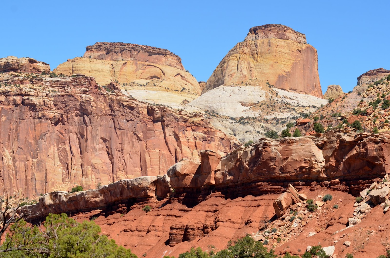
From Wiki: CRNP is in south-central Utah. The park is approximately 60 miles long on its north–south axis but an average of just 6 miles wide. The park was established in 1971 to preserve 241,904 acres of desert landscape and is open all year with May through September being the highest visitation months. We stayed here two nights (9/18-20/2015) but could have stayed another week as it a most pleasant place to just relax and drive the many dirt roads to places seemingly untouched.


Once again, we took a zillion pics, so I will post only what I feel are most interesting and ones that have stories to share.


We discovered that there were many of these abandoned mines in this area and are still considered risky to be near for any length of time.


We drove down this wash for a mile or so and canyon walls were just exhilarating to the senses.


We took several hikes while here at the park. It was really dry and very warm, so we had to keep hydrating.


Gotta take a break in the shade.

There are so many unusual yet beautiful rock formations in this park, and before this trip, we'd never heard of it. Below, Nancy blazing (literally) a trail....


This was one of the washes off Fremont River which runs through the park. The Mormons diverted many areas of the river onto the landscapes for their fields and orchards and veggies.


From Wiki: Mormons settled the Fremont River valley in the 1880s and established Junction (later renamed Fruita), Caineville and Aldridge. Fruita prospered, Caineville barely survived, and Aldridge died. In addition to farming, lime was extracted from local limestone and uranium was extracted early in the 20th century. In 1904 the first claim to a uranium mine in the area was staked. The resulting Oyler Mine in Grand Wash produced uranium ore.

I kept the camera on this guy, and several others in case I got an action photo of a fall down the mountain. Morbid I guess.


Prickly Pear Cactus?


Remnants of the old Rainbow Ranch at Pleasant Creek in the park...


Pleasant Creek which feeds into Fremont River


Yours truly below...


Majestic formations, all God's handiwork...


From Wiki: Capitol Reef encompasses the Waterpocket Fold, a warp in the earth's crust that is 65 million years old. It is the largest exposed monocline in North America. In this fold, newer and older layers of earth folded over each other in an S-shape. This warp, probably caused by the same colliding continental plates that created the Rocky Mountains, has weathered and eroded over millennia to expose layers of rock and fossils. The park is filled with brilliantly colored sandstone cliffs, gleaming white domes, and contrasting layers of stone and earth.


Above, one of the many deer resting in the field, and next to the orchards of apples, pears, nuts, peaches and you name it, and it is or was grown here by the settling Mormons years ago. They are maintained by the park service now and are open to the campers for a small fee as pick-your-own.
From Wiki: By 1920 the work was hard but the life in Fruita was good. No more than ten families at one time were sustained by the fertile flood plain of the Fremont River and the land changed ownership over the years. The area remained isolated. The community was later abandoned and later still some buildings were restored by the National Park Service. Kilns once used to produce lime can still be seen in Sulphur Creek and near the campgrounds on Scenic Drive.
Well that wraps another blog, so for now, Joe & Nancy, the RVing Beach Bums will sign off till the next blog. This blog was written and published from Georgia Vets State Park in Cordele, GA on 2/29/2016 (Leap Day).
No comments:
Post a Comment