

Inside the Fort Clatsop Visitor Center, a ranger shows on a map some of the places the Corps of Discovery visited in search of food and a place winter-over.


A statue from inside the visitor center and a few pics of pics.


Above, Nancy posing with Sacajawea and her baby, Jean-Baptiste, just outside the replica Fort Clapsot.

Fort Clatsop was the encampment of the Lewis and Clark Expedition in the Oregon Country near the mouth of the Columbia River during the winter of 1805-1806. Located along the Lewis and Clark River at the north end of the Clatsop Plains approximately 5 mi southwest of Astoria, the fort was the last encampment of the Corps of Discovery before embarking on their return trip east to St. Louis.


A few pics of the replica rooms...


Above, the trail dow to the landing on the Lewis & Clark River where the canoe fleet was docked for the winter. (Actually, they were "landed".)


Miss Nancy reading a storyboard on the landing and the pilings below. They were actually a catch and holding pen for hundreds of logs that were staged for floating down to the Astoria mills.


We visited the Deception Pass State Park across the bridge into Washington about 5 miles. Here are a few pics from their museum.


Cape Disappointment Point State Park, Illwaco, WA
From Wiki: One account has it that the cape was named on April 12, 1788 by British fur trader John Meares who was sailing south from Nootka in search of trade. After a storm, he turned his ship around just north of the Cape and therefore just missed the discovery of the Columbia River. Alternatively, the cape may have been named in November 1805 by a member of the Lewis and Clark Expedition, which had recently succeeded in reaching the Pacific, when he found no ships in the vicinity, according to the journal of the expedition as recited in the Ken Burns documentary.


Lewis & Clark were so enameled with Chinook Canoes, and, the way they could navigate them in the rough waters around the mouth of the river and the coastal areas.


Below, the light on Cape Disappointment...


Above, the jetty is undergoing some major re-shoring and maintenance by the Army COE. Below, in a different era of history, remnants of huge gun emplacements from WWII. There also big guns at Fort Colombia, back up the road to toward the bridge to Astoria.


Above, the old church building at Middle Village-Station Camp (Chinook) and below, a few pics that are at the Middle Village exhibit.

The Corps spent just 10 days here, but used Middle Village as a departure point for an overland trek to their first view of the Pacific Ocean and an exploration of the area. Historians called the spot "Station Camp" because it was Clark's primary survey station to produce a detailed and accurate map of the mouth of the Columbia River and surrounding area. This was the most detailed and accurate map he made during the entire trip.
On Nov. 24, 1805, the explorers desperately needed a winter campsite, one rich with game and near friendly tribes who would trade for supplies. To assist in deciding where the Corps should winter, the captains "Solictations of every individual." A majority of the Corps, including the Indian woman Sacagawea and the African American York decided to cross the Columbia River to look for such a place.


Below, a few pics from the WWII era...


Fort Columbia State Park is one of the most intact coastal defense forts on the West Coast, the park features a self-guided walking tour around historic gun batteries and other fort structures with scenic views of the Columbia River estuary. As part of Lewis & Clark National Park and located on the Chinook Point National Historic Landmark, all the names here get kind of confusing.


Below, the old supply building converted into the party house, and today, the Astoria Theater for live performances.

From Wiki: In 1805 the Lewis and Clark Expedition Corps of Discovery were low on supplies and traveling rapidly down the Columbia River, intending to meet one of the last trading ships of the season, hoping to secure needed supplies and to send back journals and specimens home as requested by President Jefferson. On November 10, 1805, a severe winter storm struck the area, forcing them off the river for six days and preventing them from meeting the supply ships. The group landed in a cove on the north bank of the river that Captain William Clark called in his journals “that dismal little nitch.” After the storm passed the company moved to Station Camp on the west side of Point Ellice, and camped at that location for 10 days before relocating for the winter to the location of current-day Astoria.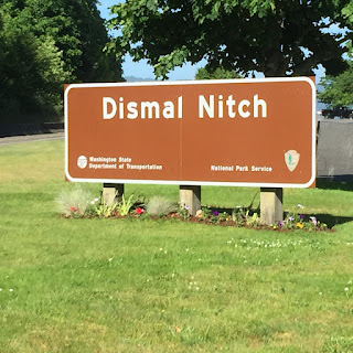

Well, that's a wrap for this blog. RVing Beach Bums, Joe & Nancy Carrier, Virginia Beach, VA, signing off till the next blog. This blog written & published contemporaneously from Lakewood, WA Panera Bread on July 10, 2015.
No comments:
Post a Comment